 Logistics, logistics, logistics! I made this page to give you an idea where you can get on or off the trail for section hiking, and to give you some driving information between a few of the main trailheads. I have also included an extensive map near the bottom of the page that has all the camp spots, and points of interest on the trail. Beyond this, there are too many other good resources for me to try to discuss every aspect of the trail itself. For that, I suggest you do your research. You can start with a good book. Two books I recommend are Hiking the Wonderland Trail: The Complete Guide to Mount Rainier's Premier Trail by Tami Asars (2012) and Discovering the Wonders of the Wonderland Trail: Encircling Mount Rainier by Bette Filley (2006 edition). Either will give you a good idea of what to expect on the trail itself. Maybe before you get the books, you should read this online article from the Seattle Times about the realities of what to expect on the trail. It has some good advice for the beginner. If you are looking for something to reference on your phone, look for the Wonderland Trail by Tami Asars app (developed by Atlas Guides) available on Android and iPhone for $15. In case you don't feel like paying that steep $15 price tag for Tami's app, there is a crowd-sourced app simply called Wonderland Trail (developed by HikerBot) available for Android. I can vouch for Tami's app, not so much for the latter, although it does have decent ratings so your mileage may vary, literally. Last but not least, check the Park Service website for details on how to apply for permits, trail conditions, etc.
Should you section hike the Wonderland or do it all in one shot? A lot of people hike the Wonderland Trail all in one go. Doing so however requires a big investment in time off from work. Unfortunately, not all of us can afford to take off 9, 10 or more days to do an extended backpacking trip. If you are a strong hiker, you can section hike the trail and do it on weekends, or better yet, a weekend plus a Friday or a Monday added to either end. This of course is based on the assumption that you can get wilderness permits on weekends.
Give yourself plenty of time. While doing the whole trail in one go has its challenges, a section hike will also require extra planning since you will either need someone to drop you off and pick you up at predetermined times, or you'll have to do a shuttle with two cars. Whatever you decide, plan on giving yourself plenty of time to get to the trailhead so that you have time to do the miles you intend to do. On section two of my WT hike, due to the long miles we had to drive to plant a shuttle car, we didn't get on the trail until 12:45 in the afternoon and we had 14 miles to hike before our first camp.
Hitchhiking between trailheads. While I don't recommend it for safety reasons, if you intend to hitchhike between trailheads to retrieve a car, it is really only practical to do so on the south-east side of the mountain between either the Sunrise, the White River, the Fryingpan Creek, the Box Canyon, the Reflection Lakes, or the Longmire trailheads - that's if it's even legal to hitch in the Park. While not impossible, the road distance between the trailhead at Mowich Lake and any other trailhead is too great for all practical purposes in regards to hitchhiking.
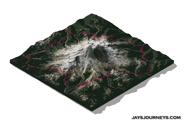
Overview Map
This is an overview map I created of the roads and trailheads for the Wonderland Trail. Clicking sections of the trail will show the mileage of that section - generally between two points of interest such as a camp site and a trail junction or another camp site. Clicking the icons on the map will reveal the name of that location. Go ahead, click around.
Wonderland Trail elevation profile

Driving between trailheads.
Below are the driving distances between the major points of entry/exit for the Wonderland Trail. These are via the closest routes, but perhaps not the fastest. These are mostly intended for rough planning. Everyone has google maps on their phones nowadays that will offer better routes depending on traffic, length, etc. The info below is just to give you an idea of how far you'll be driving for shuttle purposes.
Distances measured driving Clockwise vs Counterclockwise around the mountain.
From Longmire
Shortest distance by road to Mowich Lake - 86 miles.
Shortest distance by road to Sunrise - 58 miles.
Shortest distance by road to White River Campground - 50 miles.
Shortest distance by road to Fryingpan Creek - 47 miles.
Shortest distance by road to Box Canyon - 18 miles.
Shortest distance by road to Reflection Lakes - 11 miles.
From Mowich Lake
Shortest distance by road to Longmire - 86 miles.
Shortest distance by road to Sunrise - 83 miles.
Shortest distance by road to White River Campground - 75 miles.
Shortest distance by road to Fryingpan Creek - 72 miles.
Shortest distance by road to Box Canyon - 93 miles.
Shortest CW distance by road to Reflection Lakes - 100 miles.
Shortest CCW distance by road to Reflection Lakes - 98 miles.
From Sunrise
Shortest distance by road to Longmire - 58 miles.
Shortest distance by road to Reflection Lakes - 47 miles.
Shortest distance by road to Box Canyon - 40 miles.
Shortest distance by road to Fryingpan Creek - 11 miles.
Shortest distance by road to White River Campground - 11 miles.
Shortest distance by road to Mowich Lake - 83 miles.
Driving Distances From Downtown Seattle
Sunrise - 96 miles.
Longmire - 92 miles.
Mowich Lake - 65 miles.
Driving Distances from Downtown Tacoma
Sunrise - 80 miles.
Longmire - 66 miles.
Mowich Lake - 43 miles.
Driving Distances from Downtown Olympia
Sunrise - 104 miles
Longmire - 72 miles
Mowich Lake - 68 miles.
My experiences
Below are the links to the reports I wrote about each of my WT section hikes in the order I hiked the trail.
Wonderland Trail Section One – Longmire to Mowich Lake - Multi-day
Wonderland Trail Section Two – Mowich Lake to Fryingpan Creek - Multi-day
Wonderland Trail Section Three – Fryingpan Creek to Box Canyon – Dayhike
Wonderland Trail Section Four – Box Canyon to Longmire – Dayhike
Great insight and photo’s. Thanks for sharing! I have a Longmire to Sunrise permit (counter-clockwise, may exit at Frying Pan) at the end of Aug this year. Any suggestions or contacts for shuttle to leave a car at the exit (frying pan or white river) and get back to Longmire to start hiking? Thanks!
Cheers,
ron
Hi Ron. Unfortunately I’ve not heard of anyone doing a shuttle. If you are on Facebook, you might have luck asking on the Wonderland Trail group page. https://www.facebook.com/groups/675281582581927/
Good luck. Have a great hike.
Jay
If I could only do one section, which section would you recommend?
Gosh, you know, the whole thing is really beautiful. This is a really hard question. When I think of the Wonderland trail, the section between Longmire and Mowich Lake is always the first to come to mind. I really enjoyed Emerald Ridge, St Andrews Park, Aurora Lake, munching on Blueberries at Sunset Park. Yep, I think Longmire to Mowich was probably my favorite section.