I've broken this report up into 3 different posts. Part 1 is of my hike at Munra Point in the Gorge and for me is symbolically the beginning of my trip even though the Gorge is like 3 hours from where I live in Silverdale Washington. Part 3 is about my hike at Juniper Gulch in the Owyhee Reservoir area. This part, part 2 will be all about the road trip. The route I took and places I stopped at along the way.
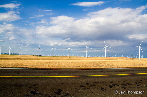
I took a couple extra days off during the Memorial Day holiday this year to take a road trip to SE Oregon. On the first day, I drove through the Columbia River Gorge and hiked up Munra Point. After Munra, I continued my trip, driving through the Gorge and eventually Dalles and onto Hwy 97 south bound driving through the Biglow Canyon Wind Farm near Wasco. The turbines here are a very impressive site to behold.

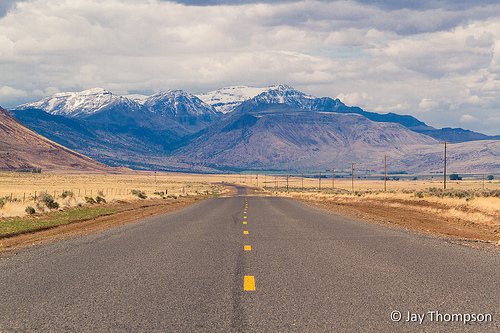
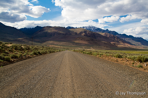
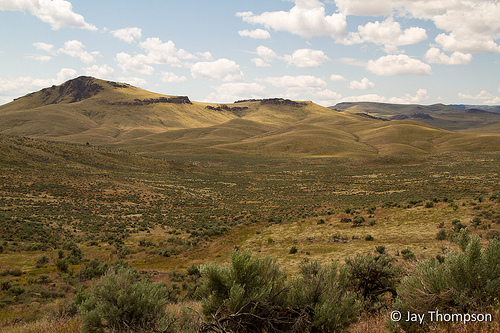
In Wasco, I hopped on Hwy 206 south. The miles go by really fast here. The views are far and wide and I considered myself to be in "big sky country" even though Montana already selfishly holds that title. If you've lived in the woods long enough, you'll know what I mean. Something about being able to see in any direction farther that just a mile or so does something special to one's well-being. The few structures out here sparked my imagination with visions of how life may have been here, 50, 70, 100 years ago. I daydream of a time when I may be able to retire and actually spend time, real time in big open spaces such as these. It wouldn't be hard for a person to lose themselves out here for a season. Get to know the land, become an aspiring ranch hand. A somewhat legitimate reason for loitering in such an area I suppose. That time is still a ways off for me, or perhaps will never come, but it's still fun to day-dream.
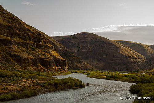
Back in the real world, I continued driving south on Hwy 206. I Eventually made my way to the crossing of the John Day River. I made it a point to stop on the bridge and take a picture. A simple view that many see as they drive by here but how many see what is just around its bend? Certainly many fishermen launch from here and see some of the river, but unlike them, I don't want to fish. I want to know the river. To explore its banks and see the sun set behind its canyon walls. To run its rapids and see it to its end. To hear its bubbling, babbling tale, and to remember it well. To live it and be part of it for a time.
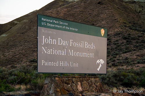
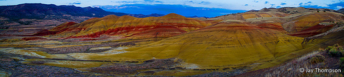
One of my mistakes in choosing the route for my trip was relying on Google Maps. I call it a mistake but it was possibly a blessing in disguise as I got to see some country I'm sure most miss while traveling this way. I had printed out my route before-hand and I made it to my destinations OK, but what I didn't realize was how many dirt roads there are in Oregon. I was on my way to see the Painted Hills. I followed the directions Google gave me and finally made it to the turn off on Rowe Creek Rd which I almost missed. It was paved but not for long. It turned into a dirt road shortly after turning onto it and I followed my directions to get to the Painted Hills via this back way which turned out to be the first 25 dirt road miles of several hundred on this trip. I could have perhaps made it to my destination faster by staying on the paved Hwy, but I wasn't complaining too much. The only hurry I was in was to get to the Painted Hills by sunset which at this point I figured I was going to miss anyways, but not by much. And I would still get to photograph the area a bit before night laid down a complete shroud of darkness .
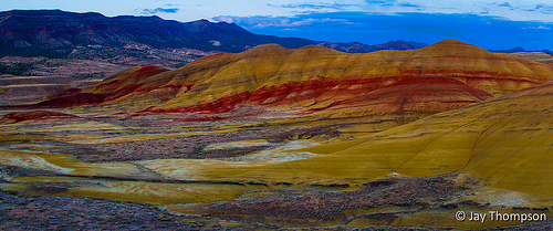
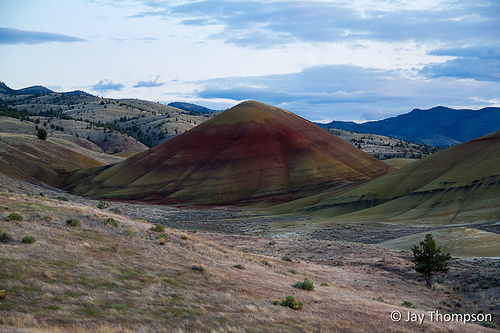
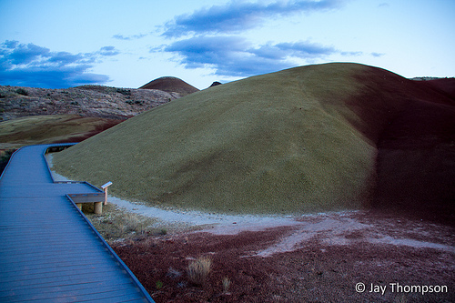
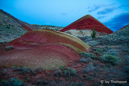
The Painted Hills were new to me. I've never seen anything quite like them. Nothing grows on the Painted Hills. A sign read that they are made out of bentonite, a kind of clay which expands and contracts greatly as it soaks up water and dries. The top layer has a kind of popcorn like size and shape. The Painted Hills area is well worth a visit but it's not very large. This worked to my advantage as I got to see everything I wanted to see in the short half hour or so before it get too dark to really photograph anything worthwhile. I even got to hike a short boardwalk called the Painted Cove Trail that looped around one of the smaller hills.
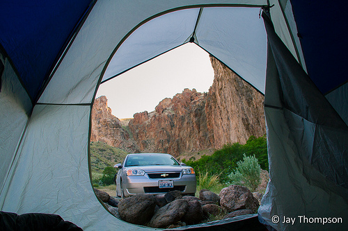
After the Painted Hills, I drove the final 45 miles or so, now on Hwy 26 and off the dirt road to my final destination for the night, the Fish House Inn and RV Park at Dayville Oregon. I had called about a week ahead to reserve a spot for my tent. Probably not the wisest choice for me to wait until the last-minute to reserve a spot since it was Memorial Day Weekend. I figured the place to be full. The owner and caretaker of the place Mike answered and said "sure you can flop a tent out on the lawn when you arrive". He was worried only about the bathroom being overused as he was fully booked. When I arrived, it was pretty dark. I rang the caretaker doorbell on the back of the office but no one came. I went ahead and set up my tent over near a picnic bench on the lawn. I didn't see any hardened camp spots, just well manicured lawn. Took a free shower in the clean bathroom provided. When I woke the next day, I could see the place was not very big and there was only one other tent besides mine. There were a lot of RVs and campers but I hadn't heard them at all throughout the night. When a lot of people think of RV parks, they think of KOA type of experiences where you can practically reach out your camper window and touch your neighbor's RV. This was nothing like that. I won't stay at places like that either. I found Mike as he was leaving to run an errand, paid and thanked him and said good-bye. I didn't get any pictures of the place but I highly recommend staying there if you are going to be going through the area.
I had seen a lot on my first day, and my ideas for the trip were going as planned. I continued today driving further east on 26 and eventually getting to Hwy 395 and headed south toward Burns. For me, this was the more boring part of the drive, and it was already close to noon by the time I got to Burns. Since I had rushed out of camp in the morning without eating, I found a fast food joint and grabbed a burger which turned out to be the only food I bought the entire trip. The rest of my meals were from the provisions I brought from home and shopping I had done prior to the trip.
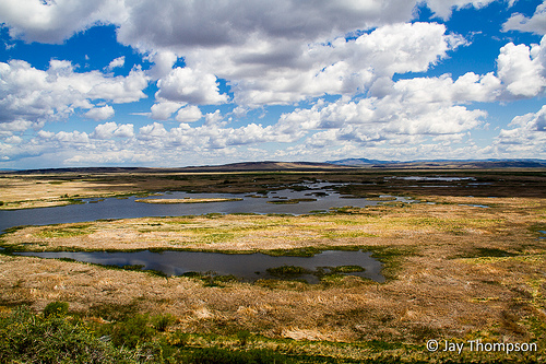
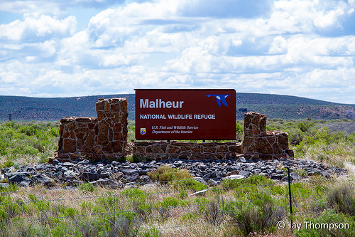
I was actually quite proud that I had been so thrifty, instead spending money only on gas (out of necessity actually, gas was really expensive). In Burns, I got on Hwy 205 and continued south driving by Malheur Lake which is a National Wildlife Refuge. I heard that the area could be bad with mosquitoes but I guess they had not hatched yet this season since I didn't see any. The lake itself to me was kind of uninteresting, and as a funny kind of coincidence, I discovered Malheur means misfortune in French. It was named this after trappers found nothing worth trapping in the area and left. Just past the lake, there was a turn off to a viewpoint called the Buena Vista Overlook that offered a nice view but other than that, I can't recommend much in this area unless you are into birding.
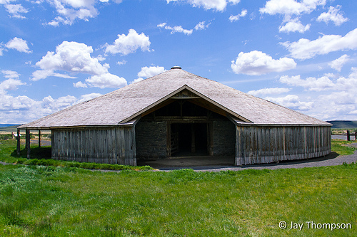
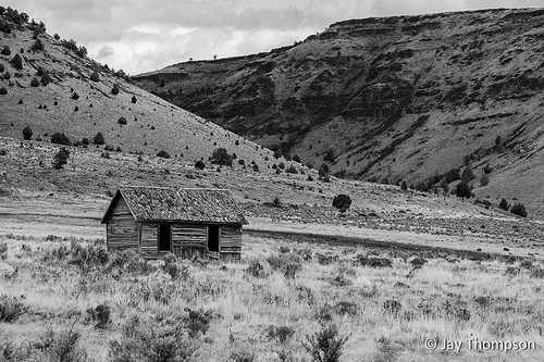
Back on the road and shortly after the overlook, I saw a sign for the Pete French Round Barn. I had seen pictures of this barn online from someone who had done a trip similar to mine recently and the idea of seeing it for myself intrigued me. I didn't really know anything of the place or who Pete French was but I am always up for adventure. I could look up the historical stuff later. Besides, if I knew what to expect beforehand, it wouldn't be as exciting. Turned out that the road going out to the barn was part of a National Backcountry Byway called the Diamond Loop.
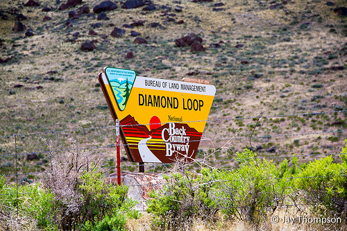
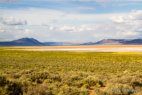
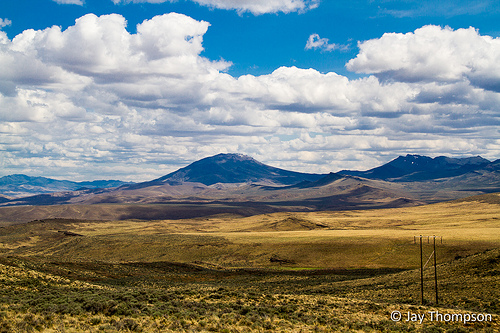
Much of the loop was, yes you guessed it, dirt road. This was a very scenic back route that doesn't see much traffic. I'm glad that I decided to go out this way and see what it had to offer, because as well as seeing the historic round barn, I saw some beautiful countryside, which by the way included some partially obstructed views of Steens Mountain. Part of the loop involved a side trip to see the Diamond Craters. Geologically speaking, this area is fascinating as it has, as the BLM describes on the Diamond Craters website "... some of the most diverse basaltic volcanic features in the nation clustered within a small, accessible area". Interesting as it was, I had been to the big island of Kona Hawaii last year and saw Kilauea so ... not as impressed as maybe I should have been, but it was still very interesting nonetheless. I had now burned a big chunk of my day in this area. I was supposed to have been to the Alvord Desert by now and I still had miles to go.

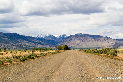
When I got to the town of Frenchglen, I decided I better fill up with gas because I wasn't sure when I would see another station. It was $4.76 per gallon. In Oregon, you're not allowed to pump your own gas. I think it is more to keep people employed than to protect the public from heath risks or anything like that. The kind old lady that runs the store there looked tired. Tired as if a lifetime in Frenchglen had taken its toll. I asked her if she minded if I fill it up myself and she happily obliged as she said she was favoring a bad hip. Back on the road and now making my way around Steens Mountain, I found this area to be the most scenic of the trip.
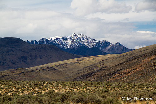
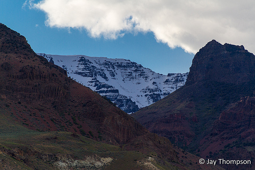
Steens Mountain was after all, the reason for the trip to begin with. It is sometimes called the Jewel of the Oregon High Desert and for good reason. It is beautiful. It is big as well. It rises a vertical mile above the desert floor to an elevation of 9733 feet. The mountain stretches for 50 miles from north to south. The Wikipedia entry for Steens says "It is sometimes confused with a mountain range, but is properly a single mountain." Due to the fact that there was still too much snow on it and the gate was still locked, I would not be able to drive to the top. This adventure would have to wait for another day but I was not disappointed. I was elated to know that I would be coming back for more adventure and to see more of the beauty that Steens has to offer.

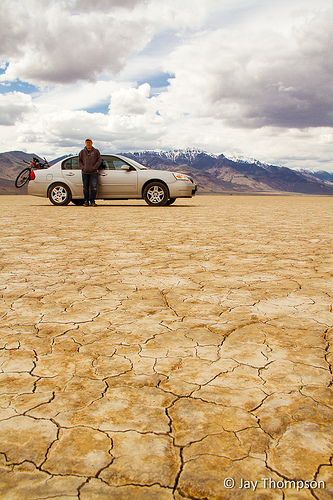
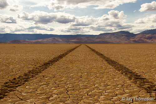
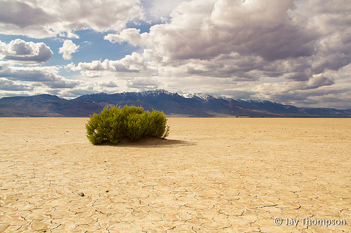
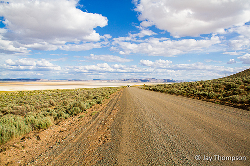
Soon, I came to the southern terminus of what I was calling my SE Oregon road trip. Fields Oregon is just a scant 20 or so miles from the Nevada border. I thought about driving down to the border just because it was there, but I had other business to attend, the Alvord Desert. I have an Oregon-Nevada border crossing by foot in mind next year during the same time frame in the Pueblo Mountain Range on the High Desert trail. Reaching Nevada today by vehicle was very low on the priority list. In Fields, at the intersection, you take a left. If you go right, you stay on Hwy 205 and hit Nevada. Going left, the road soon turns to dirt and remains dirt for the next 50 or 60 miles. After driving about 15 miles on this road, I finally come to my first big view of the Alvord Desert. I keep driving a ways and finally find an entrance to get out onto the playa. The road was probably better suited for a four-wheel drive high clearance vehicle, but I seem to do OK in my sedan. I arrive on the desert floor and get ready to test out the driving conditions.


At first I took it a little slow, not really sure what to expect. It was a little surreal, I mean this is a lake bed after all. I had seen pictures of the place when it was flooded. What if I inadvertently drive over a spot that was still wet and got my car stuck? This was like an alien world to me. Indeed the cracks in the ground almost had a moist look to them like it had dried up not too long ago, indicating to my uneducated eye that it might not be safe. I stopped, opened my door, felt the ground. Dry as a bone. Seeing, or maybe in this case feeling, is believing. In the distance, not much more than a speck really, I could see something moving across what at first looked like water but I knew was just a mirage. A little dust cloud rising behind it much like a rooster tail. A motorcycle? Closer inspection revealed larger specks, but these were stationary. I saw some tire tracks going over towards the specks so I followed them a ways figuring it was "safe". I was amazed when I got closer, to see a whole caravan of Volkswagen camper vans parked in a corral just like those covered wagon trains did back in the old west. What an interesting group that must have been.

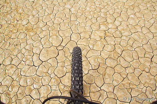
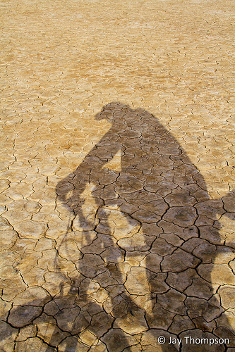
After my initial fascination was over and my irrational fear of sinking in to my hub caps had subsided, I found another set of tracks that went east across the playa. I steered my car in their direction and put the pedal to the metal. I was going about 90 before deciding to slow down. I drove about 4 or 5 miles across the playa and stopped. I got out of my car and took my bike off its rack and started riding. I rode with the wind at my back with no particular destination in mind and headed in an easterly direction. I rode as far as some scrub bushes that grew along the edges of the basin and turned around. "Where the hell is my car?" I muttered. I must have ridden 2 or 3 miles and when I turned around I didn't see it at first. "Ah there it is". Just a silver speck on the horizon. I screwed around some more on my bike and took some more pictures. It was kind of windy and I was going against a considerable headwind on my ride back to the car but I eventually made it back.
I had planned on camping on the playa that night and spending even more time in this part of the world, but something I hadn't planned on became a problem for me. I was running out of room on my camera's CF card. I purchased a new camera earlier in the year and I only had one 8 gig card for it so far. The new camera takes different kind of memory card than my old camera and it isn't cheap to buy. I made the decision right then and there to get back in the car and drive on to the Owyhee Reservoir area to camp for the night. I'd be cutting my trip short but what good was the trip if I couldn't record any images? I needed to start moving if I wanted to get to camp before dark. Owyhee, by the way is an old English spelling of Hawai'i and is pronounced much the same way.

The drive back to the road was uneventful except for the fact that I wasn't quite sure where the entrance was. I drove to where I thought the entrance was and started driving along its edge looking for the entrance. This went on for about 5 minutes before I started to get worried and wondered if I should have taken a GPS reading when I first got here. At last I found it and drove out to the road. I still had about 40 miles of dirt road to go before I got to pavement so the going was slow. Well, slower than hwy driving. I was still doing 45 on the dirt which wasn't too bad I guess. I would have made even better time if I wasn't stopping so often to take pictures here and there. I couldn't help myself. The space on my card was getting lower and lower. If I didn't stop, I would have no space left for the rest of my trip.

Finally reaching pavement and getting on to a real road on Hwy 78, I headed east. God! What beautiful country! I was driving along and spied an antelope bounding along. I wasn't expecting this on my trip. I hadn't seen an antelope in years. What a treat! I kept driving along and just a few miles away from where I saw the antelope was a band of wild horses, complete with mares, stallion and a foal. "I must be dreaming" I thought. How often have you seen horses in the wild? This moment really made me wish I had a better zoom lens. The mares all had their backs to me while the stallion, yes he was black, was stomping and prancing around. He never turned his back to me but he did seem to want to stay close the foal. I really need to come back to Steens soon.


Back to thoughts of driving, I eventually made it to Hwy 95, where the road takes a north-easterly direction. I crossed over the Owyhee river near Rome Oregon. Rome is named after a geologic formation known as the Pillars of Rome. Given more time I would have liked to have stopped to see them for myself. Unfortunately time was growing short as sunset was fast approaching. On I drove and actually made it to Idaho. I wasn't planning on going to Idaho so I was initially shocked. Checking my map indicated that I was just near the border for a short time before going back in to Oregon to find a place to camp near Leslie Gulch in the Owyhee Reservoir area. I finally made it to the McBride Creek turnoff (more google directions and dirt road driving) and saw signs for a place called Succor Creek campground. Sounded good to me. The sun was beginning to set.


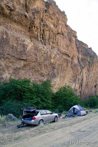
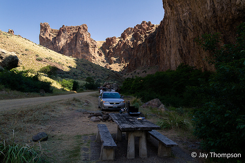
When I finally made it to camp it was dark, and it looked like all the spots were taken so I kept driving. The road going into Succor Creek camp was windy and twisty and I knew I was going down into a canyon. I finally found an empty spot at a turnout along side of the road that had a picnic table and set up camp for the night by headlamp. I quickly made something hot to eat while watching some field mice running in and out of the bushes and making mad dashes for some food crumbs that someone was kind enough to leave on the ground under the picnic table.
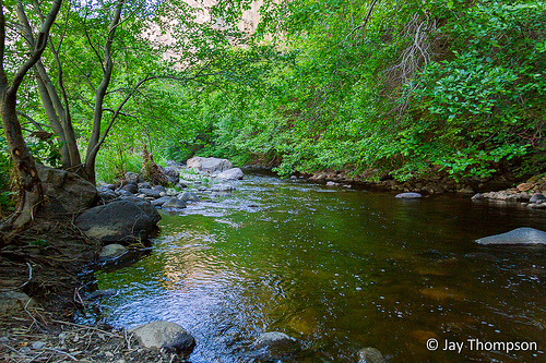
On the drive in, I could tell I had descended a ways. By the light of the moon, I could make out the outline of canyon walls towering above me. I was very curious to see my camp site in the day time. When morning came, I was not disappointed at all. Succor creek was lovely. I was very excited to start my day and go see what my next destination had in store.

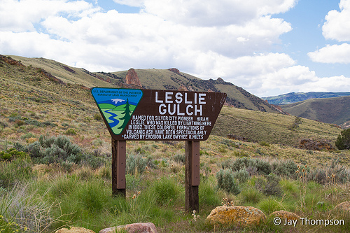
After breakfast and recovering from a catastrophic coffee failure that involved me knocking my stainless steel cup off the table which wrenched the lid off and spilled the hot liquid all over the ground and splattered on to the front of my car, I drove out of Succor Creek. The drive, much as the night before was on dirt but otherwise uneventful. I would need a new air filter when this trip was done. It was very dusty. On my way in the night before, I saw the turn off to Leslie Gulch. It was just a matter of back-tracking to it and following it to find a place to hike.
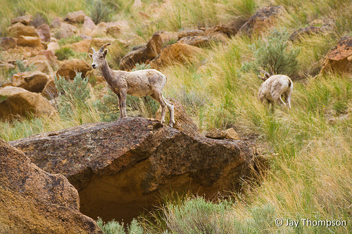
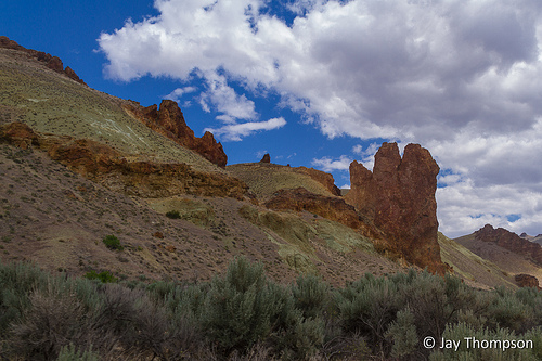
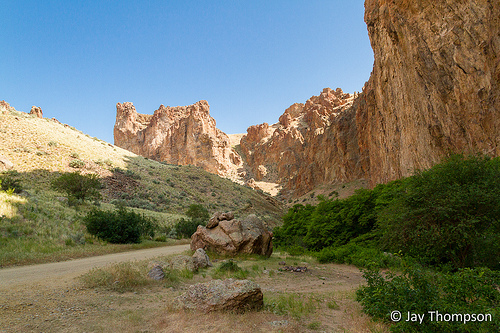
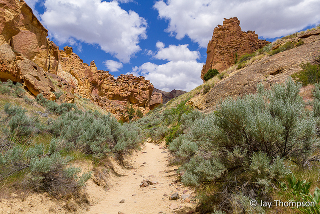
I knew there were places in Leslie to hike but I admit that my pre-planning for this part of the trip left something to be desired. I made my way down the dirt road going into Leslie Gulch, once again following a canyon down towards the Owyhee Reservoir. I was surprised how pretty the place was, stunned actually. I knew it would be nice but had no idea. I'll be honest, there is a road that goes smack down the center of Leslie Gulch and it was already getting warm, no, hot. Hot and dusty. I figured from my meager planning that Leslie Gulch's main feature was a trail, not a road. I passed some cars that were stopped along the side of the road and people were outside gawking at something. I stopped and looked and there was a young bighorn sheep on the hillside or as someone later jokingly told me, "it was a little bighorn". What a neat place this is. Again I got to see something on this trip that was totally unexpected.

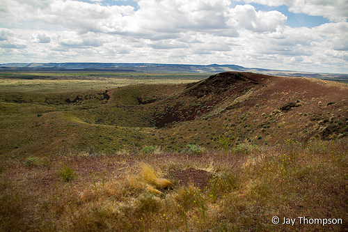
Still driving, I passed a sign for the Dago Gulch trail. Leslie must not have been too friendly of a man to name one of the gulches Dago, but then again, I guess times were different then. I passed this trail and continued on. Another trail appeared, Juniper Gulch. I figured I would drive all the way down to the reservoir and see what other trails were along the way. I made it to the end of the road (never did see the reservoir) and turned around. I made my way back to the Juniper Gulch Trailhead and got my pack ready for the hike. Adventure was ahead. I had no map, no compass, and no idea where the trail might lead. Only a backpack on my back that really only served to carry 2 liters of water. I was so excited that I even neglected to pack some food.
Stay tuned for part 3 of my trip,The Juniper Gulch of the Owyhee Badlands - SE Oregon Road Trip Part 3
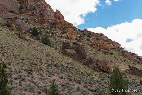
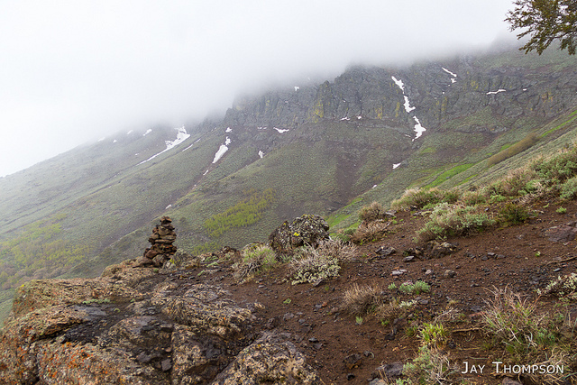
Enjoy these other pictures from the trip.


Nice report Jay! I’ve wanted to go down there for awhile, and this is motivating.
Loved the read. Might have to borrow some of your route to come home from Burning Man this year.
Thanks Megan. You really should take some of the route I took though Central Oregon on your way home. You won’t regret it. Beautiful country, especially for us desert lovers!
Not sure I’ll be a desert lover on Labor Day weekend, but if I have to drive through anyway, it might as well be an interesting route like you did. Love those gulch pix.
Amazing! How much time did you spend on your road trip? I was thinking if heading to Leslie Gulch in April (from Portland). I have 4 days and wanted to get the most out of them… I like the route you took, but wasn’t sure if their was enough time.
Hi Jen. I took 3 days. It was a whirlwind tour. I was planning on being more leisurly but it didn’t work out that way for reasons I can’t quite remember. If I did it again, I would spend more time in the Owyhee area or plan the trip a little closer to summer so I could drive up to the top of Steens Mountain. I also would have liked to have checked out the hot springs there. So little time – so much to see.
Wow, beautiful pictures and a great virtual tour! I am from NE Oregon, and have only visited the SE side a couple times. I certainly didn’t see any of the beautiful sights that you have shared. I will certainly be making a trip in the near future to see all that is there to offer! I am curious how this trip would be during the late fall, early winter timeframe (late oct-early Nov).
Wonderful road trip and report about Juniper Gulch. We’re driving in from the Tahoe area and I KNEW there had to be a gem hiding around SE Oregon. Beautiful shots. Hope we can keep the kids going all the way to the saddle!
I just read this (2 months after the fact sorry). I hope you had a wonderful trip. I definitely need to get myself back to the Owyhee area soon.