Taking advantage of a break in the weather, I headed out once again to do the Ozette loop on the Washington Coast. My primary mission was to arrive kind of late and photograph the sunset, but truth be told, I was feeling rather un-inspired this trip and skipped the sunset.
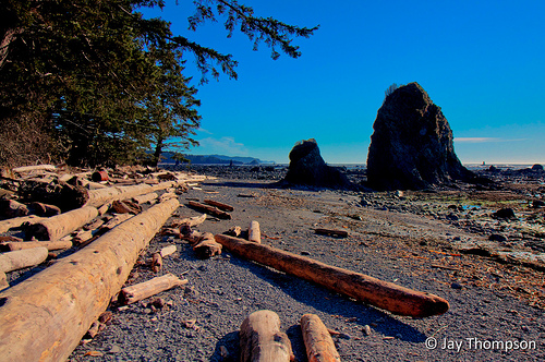
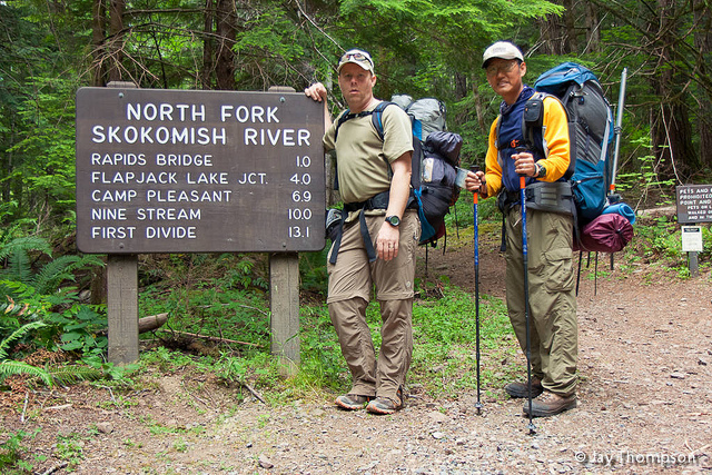
The loop consists of two trails and a beach walk. This trip is sometimes called the Ozette Triangle due to is shape on a map. Each segment about 3 miles each for a total 9 mile loop. One part of the loop, Cape Alava, is actually the westernmost spot in the continental United States, worthy of a trip in itself. It is about a 3 hour drive to get out there from Silverdale. There are lots of places on the web that offer directions and route information so I'll skip that step this time around.
One of my favorite things to do before a hike is to research the area I'm going to. Generally this research is nothing more than an internet search but sometimes a trip to the library is also in order. This time my research was actually post hike since I have already been to Ozette on another occasion. During my research this time around, I did an internet search for "swimming to Ozette Island". Now I'll let you know that I'm smart enough not to try something so foolhardy. But you know, hopefully by asking an interesting question, I would get an interesting answer. Because you know, there are no stupid questions. Right? Anyhow, in typical google fashion, I got a lot of hits for the query but one really stood out, *"My 40 years on Ozette Island". When this guy was a young man, him and his friends made a raft using long spike nails and driftwood and paddled out to the island. His story is very reminiscent of a Tom Sawyer type of tale. He even claims to have spent a whole summer on Ozette one year, leaving only long enough to restock his supplies. You really should read his tale because it is very interesting. Poor guy got swept out to sea once for four days because he mis-judged the currents going out there. I highly recommend checking out his story.
- This was originally an online newspaper article that disappeared, then I found it on his website, but he deleted his site, now its available as an answer to a question on Quora. Why anyone would use Quora is beyond me. Especially for such a great story. Sorry Robert. Please stop deleting your story! I don't normally do this sort of thing but I've backed up this story as a PDF, just in case it gets lost forever. Robert if you see this and you don't want this shared, I will delete it on your request.


WOW! Beautiful! Wish I could get Ron to go out to the ocean with me!
Funny you should say that. The last time I was out there, I ran into Ron, Cheryl and Mike. They were going the opposite direction I was.
hehe….that must have been the time they camped there before I moved up here.
That is probably the last time he went to the ocean, and he tells me about that trip all the time and says, “I really need to take you out there”.
Cool that you were able to do the loop. The only time I’ve been there in the winter the tide was too high to walk on the beach and I barely slept thinking about all the flotsam in the campground.
Yeah, good idea to check the tide tables before driving all that way. Its a long drive so conditions need to be pretty good before I’ll head all the way out there. It was .2′ on Saturday at 5 pm at Neah Bay so I figured I was safe.
Nice report. I need to do the loop someday…
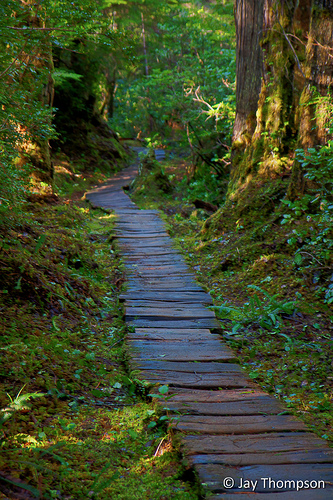
I really like your boardwalk photo, Jay. How about posting it on the West Sound Photography Group website? Forest images are hard to shoot, especially on a sunny day. You really brought out the tecture.
fantastic photos jay .. i like how the elevation gain is like 200′ if you climb up the “peak” at sand point
Love that hike! Beautiful pictures!
Thanks everyone. I just realized that I didn’t even mention on the blog all the eagles flying around out there. I remember not so long ago, a person would be hard pressed to see a bald eagle in the wild. They seem so common nowadays that they are almost an afterthought. Unfortunately my camera set up is not so good for birding.
Jon, I like that image also. Unfortunately its kind of blurry if viewed much larger than what I posted. If I had used a tripod, it would have come out much better. HDR has come a long way…
Hi Jay! This is Jason (friend of Lance, Ken and Kelsie from over on Flickr). I just wanted to give you a big thumbs up on your blog, it’s a great site. Thanks for sharing about the Ozette Loop. Gosh darn it, I came really, really close to going there last weekend. At the last minute I decided instead to go up to Mt. Rainier for a little snowshoeing.
I like the looks of Sand Point. I can’t wait to do the loop hike, the coast out there is amazing. I overnighted at Cape Alava last year, just did the boardwalk there and back.
@Jason
Hey Jason, thanks for the kudos! It was a nice day for sure but sure is a long drive for a dayhike. I want to go out there again sometime. I have some unfinished business I need to take care of involving some abandoned buildings. Specifically a cabin and a barn that are not too far off the trail that can be seen on Google Earth. Looks to be a great photographic opportunity.
Perhaps we can all get together this year for a photo hike somewhere.
Talk to you later.
Jay
Hi Jay,
I saw your reference to my many trips to Ozette, including the one in 1998 when I got washed out to sea for a few days. Yes, it is all true. Just thought you would want to know.
Robert M. Blevins
@Robert M Blevins
Thanks for sharing your amazing story Robert and for reaching out and signing my guest book. It seems that there are so many “hiking celebrities” nowadays online, that it is a rare pleasure to read stories from a true adventurer.