Hiking the Lost Coast Trail: Mattole Beach to Black Sands Beach
In June of 2018, I set out with my son Hayden and friends Linda, Ahmis, Andrea, and Brian to hike the Lost Coast Trail, one of California’s most remote backpacking routes. Stretching about 25 miles along the rugged King Range National Conservation Area, the trail runs from Mattole Beach to Black Sands Beach.
Why the Lost Coast is Remote
Unlike most of the California coast, this stretch has no roads. The King Range mountains rise sharply from the ocean, their cliffs unstable from frequent landslides and their slopes battered by pounding surf. Engineers had no way to build through, so the highways were routed inland, leaving this coastline untouched.
That’s what makes the Lost Coast so special - a place where mountains meet the sea, where tides control your pace, and where you can walk for days along the Pacific without ever crossing a road.
Trail Logistics
We began by dropping off our vehicle at the Black Sands Beach trailhead near Shelter Cove. From there, we caught a pre-paid shuttle that carried us north to Mattole Beach, our starting point. Having the shuttle arranged made the trip stress-free — our car was waiting for us at the end.
Mileage: ~25 miles
Duration: 4 days / 3 nights
Permits: BLM backcountry permit required
Bear Canisters: Required for food storage
Day 1: Mattole Beach → Sea Lion Gulch (~5 miles)
We stepped onto the sand at Mattole Beach, packs heavy and excitement high. After a few miles, we reached the weathered Punta Gorda Lighthouse, battered by fog and ocean winds. By late afternoon, we arrived at Sea Lion Gulch, our first camp.
True to its name, the offshore rocks were crowded with barking sea lions. As we set up camp together, their calls mixed with the crash of the surf, creating a soundtrack that carried into the night — a wild, unforgettable welcome.
Day 2: Sea Lion Gulch → Spanish Flat (~7 miles)
This section tested us — long boulder stretches slowed every step, and the tide dictated when we could move. Still, the views kept us going.
We reached Spanish Flat, a wide grassy terrace perched above the ocean, and set up camp. The openness felt different from the rocky coves we’d passed before. It was very windy here, but we found an amazing wind protected site in a grove of trees near the creek.
Day 3: Spanish Flat → Miller Flat (~6 miles)
We pressed on through sand and shallow creek crossings until arriving at Miller Flat, one of the most scenic camps on the trail. A broad creek braided into the surf, driftwood lined the beach, and the ocean stretched endlessly before us.
Hayden skipped rocks at the creek while Ahmis and Andrea walked the shoreline, their laughter echoing in the salt air. It was the kind of camp you want to stay at longer, but the trail kept calling.
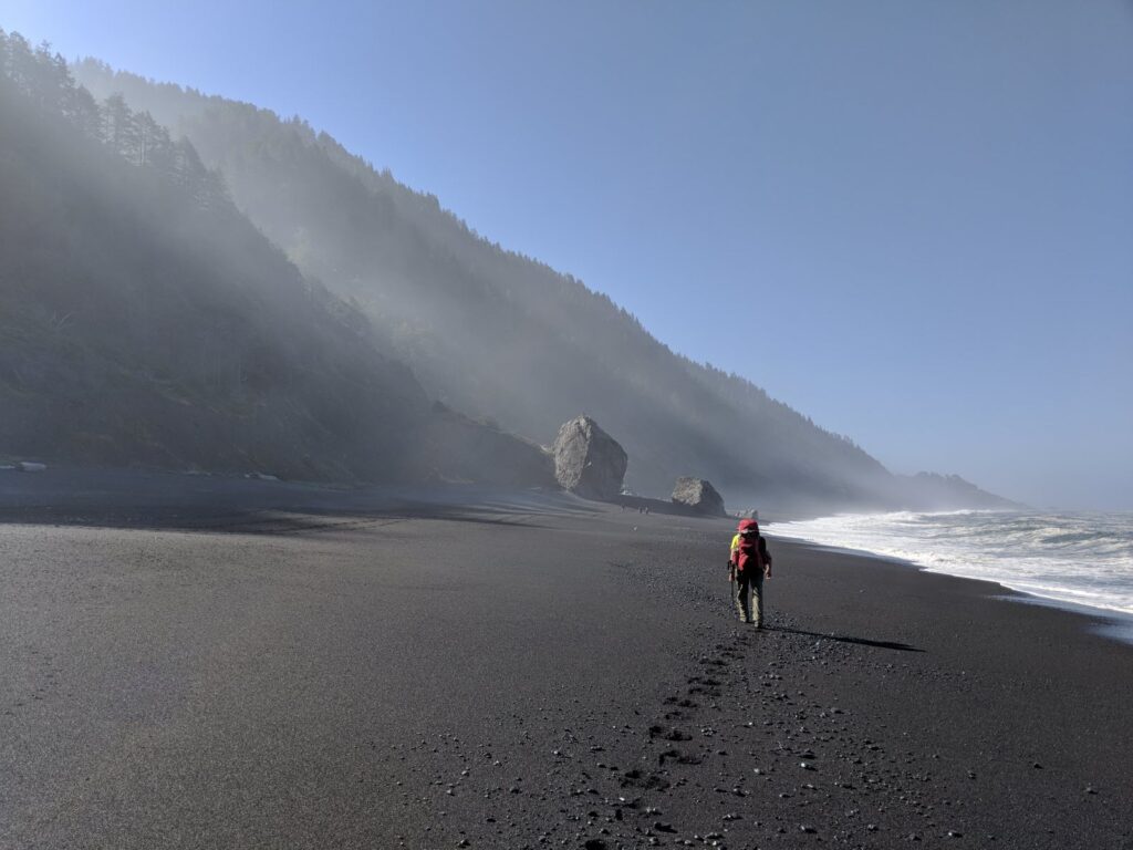
Day 4: Miller Flat → Black Sands Beach (~7 miles)
The final push tested us. Black Sands Beach is made up of shifting dark pebbles that swallow your footsteps. Every mile felt twice as long, but step by step, we closed the distance.
At last, Shelter Cove came into sight, and our car was waiting where we had left it days earlier. We finished tired but proud, knowing we had walked one of California’s most rugged and remote coastlines.
Key Tips for Hiking the Lost Coast
- Tide Planning: Certain headlands are impassable at high tide. Carry a current tide chart and plan carefully.
- Shuttle Logistics: Arrange a shuttle before your trip. Drop a car at Black Sands so it’s waiting at the finish.
- Expect Slower Mileage: Cobblestones and sand cut your pace in half compared to normal trail miles.
- Water: Streams and creeks are frequent, but always filter or treat.
- Flora: Be on the lookout for poison oak. It is abundant in places along the trail.
- Fauna: Expect sea lions, elephant seals, elk, deer, bears, and plenty of shorebirds. Bear canisters are required.
- Weather: Fog, wind, and rain are common even in summer. Pack layers and be prepared for wet gear.
Final Thoughts
The Lost Coast Trail is more than a hike — it’s a rare chance to experience California before roads and development. Our group — Hayden, Linda, Ahmis, Andrea, Brian, and me — carried out sore, sandy, and grateful. The days between Mattole and Black Sands gave us not just a backpacking trip, but a shared memory of walking the edge of the Pacific together.

Disclaimer: I used AI to help write the structure of this. I sat on this post for 7 years before finally publishing it. I hope you can cut me some slack if it reads a little off.

Now that is a bucket list trip to be proud of. Never backpacked it, but have been to your start and end points. The Lost Coast surely earns its name. Thank you for sharing.