The Back-Story
I had tried unsuccessfully 3 times to hike the High Divide loop this year. The first time I just got lazy and decided that a weekend at home sounded nice. The second time, my job at the last minute required me to be at home for some on-line training over the weekend. The third time I was due for an overnight hike and thought I would drive out to the campground at Sol Duc on a Saturday, camp and get a really early start the next morning and do the whole loop in a day. As I was packing to leave on Saturday the 19th, I got a phone call and learned that my brother had passed away. Needless to say my plans for the weekend had changed. I won’t get into all the details but I will say that his passing was unexpected and the cause at this point is unknown. Needing time to reflect on his life, needing some time to myself to reflect on the things that are important to me and my family and really needing to finally get this trail on my ‘been there done that’ list, I decided to head out on Saturday the 26th of Sept 2009 to hike it.
The Hike
I got up at 4:45 AM and was out the door by 5:00. Driving from Silverdale, I got to the trailhead at 7:15 AM, beating Google Maps drive time prediction by 15 minutes. I was on the trail at 7:20 and it was already light out but the sun had not yet arrived in the Sol Duc River Valley.
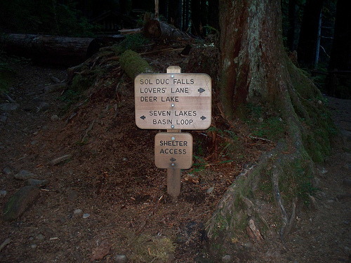
Taking my time hiking, not wanting to maintain a breakneck speed, yet not taking much in the way of rest breaks, I figured if I maintained a 2 mph pace throughout the hike I would be done with the hike in about 9 hours or so. I figured I should be done around 4:30 PM giving me plenty of daylight left as this time of the year it gets dark around 7:15 PM. So after hiking for a couple miles, I had Yogi on the brain and I was intermittently calling out “hey bear, Yogi bear” to give warning to any bears that might be in the area, even though I knew they were probably all up in the higher alpine zone eating berries. After calling out to the bears on my third or fourth time, I heard a crashing in the woods to my left. I looked up to see what was moving and it was a big Roosevelt bull elk. He ran up the trail in front of me and paused long enough for me to take his picture but my flash went off and the picture came out black. The elk ran again and I figured he was gone so I put my camera away. No more than 500 yards up the trail, I look up and there he is again, standing in the middle of the trail. I dug my camera out to shoot him but he was on to me and he bolted again. OK, this time I’m not going to put the camera away. I hiked on and he was on the trail again just like last time except now I had my camera out, I just needed to turn it on. Snap, damn flash again! This time he runs up hill. I tried desperately to take his picture but it just wasn’t meant to be I guess. I did get one but it was so blurry you can barely tell there is an Elk in it. Oh well.
I hiked on. Before coming here I had asked a few people which was the best direction to go on the loop. Clockwise or CCW? I received advice from both people claiming one way was better than the other. In the end, I listened to my friend Mike’s reasoning that the lighting was better for photos during the time of day I would be hiking if I went CW, but I can see why a lot of people would go the other direction, the views are different. If you go clockwise, you will have a long gradual approach before you gain much elevation. It is mostly a river valley hike in the woods for a good 5 or 6 miles before you get many views. Eventually you do start to climb a little and you will get to Sol Duc Park where there is a campground.
I didn’t see anyone at the campground when I arrived, in fact I only saw one couple on the trail up to this point. They were camped at the little campsite at Rocky Creek near the Appleton Pass junction and it looked like they had just woke up. I had already been on the trail for a couple of hours by that point. When you get close to Sol Duc Park, the forest opens up a little and there are some nice meadows filled with blueberries.

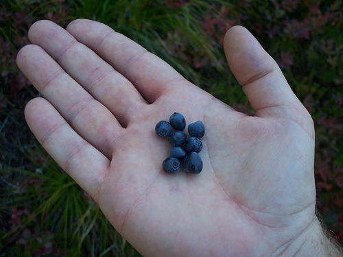
My sense of smell is not what it used to be, due to allergies and medications to allergies I have taken in the past. Something has to have a pretty strong scent usually before I can smell it, so maybe it was my imagination or maybe it was real, but I could swear I could smell the blueberries. It smelled just like blueberry pie to me, and it was such a strong scent. The blueberries themselves were everywhere. I stopped several times to munch on them, they were fantastic. I don’t think I’ve ever seen so many blueberries, the bushes were just loaded with them. The bears wouldn’t go hungry this year!
So after Sol Duc Park, the trail climbs again for a mile or two and crosses a little stream. The creek is the outlet stream of Heart Lake. I have seen Heart in pictures on-line and in books for many years and was excited to see it in person. When I got close, a couple returning from their overnight hike stopped and I asked them if they had seen any bears. The gentleman said that he saw the biggest bear he had ever seen the night before near the privy and said it must have weighed at least a thousand pounds. I pointed out the bear I could see up on the mountainside that looked like a speck it was so far away.
Him and his wife said they saw it earlier but had lost track of it and were happy to see it again. Now I don’t know if black bears get up to a thousand lbs or not, but I will take his word that it was a big bear. I’m not surprised really with the amount of berries they have to eat this year. So I finally reach Heart Lake and I’m not too impressed.
Maybe it’s all the people congregating near the outlet stream as I first see it, I don’t know. I didn’t even stop. I just kept on hiking past it. Once I got near the top and looked down, I was much happier and could see the famous heart shape it was named for.
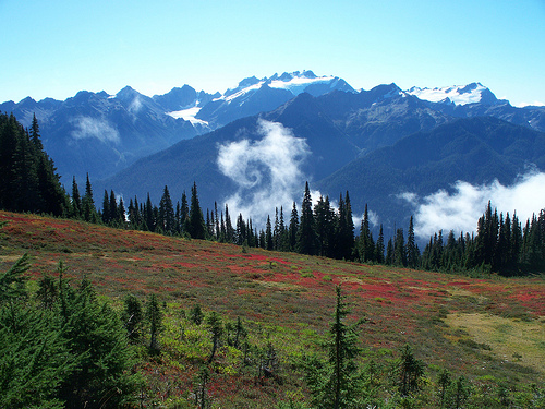
I was very close to my first views of Olympus and I was pretty stoked! I hiked on and finally reached the divide. It was magnificent. Olympus was much bigger than I imagined. Of course I had seen Olympus before, just never this close. I was very impressed. I hiked a little further and stopped to take a bunch of pictures and videos. I could see clouds down in the Hoh Valley and I wanted to make sure I got some good shots before any clouds obscured the view.
After taking a bunch of photos, I was standing there just mesmerized by the beauty of the whole thing, reflecting on the hike. Thinking about my brother and the life he led. Thinking about my life and what I could do to improve upon it, how I could be a better husband and father. All of a sudden, during my reverie, some of the clouds from the valley started spinning around all crazy like and I took what I consider to be one of the better photos I have ever taken. It certainly is odd to say the least. I won’t go so far as to say I see Jesus in it or that its anything other than a big swirl in the cloud, but look at it and let it speak for itself. I will say not to look too long though or the spinning vortex will hypnotize you and suck you into another dimension.
I don’t think I could ever come close to taking that picture again, even if I made it my life’s ambition. I think it was a one in a million shot, at least for me.
So getting done with the photo shoot, I hike on and start seeing more people on the trail. I get to a point where I can finally see the Seven Lakes Basin and I pass a guy with a day pack coming from the other way. I said to him “nice day for a day hike”. He said it was and that he thought we were at about the half way point. I looked at my GPS and we were indeed about 9 miles into it. The trip was half over. On I hiked with Olympus on the left of me and the Lakes Basin on the right. Expansive views in every direction.
These are the reasons for which I hike. Soon I came to a little side trail and there was a guy sitting there picking blueberries. After consulting my map I came to the conclusion that this was the side trail to Bogachiel Peak. I asked the blueberry picker how far it was to the top and he said “only five minutes, definitely worth it”. Two minutes later as I stood at the top, someone’s cell phone rings and he starts a conversation with someone else, laughing about how he can’t believe he has reception up here blah, blah, blah, blah, blah. Bogachiel was too crowded for me so I took a couple pictures and left.
The berry picker asked how I liked it and I said it was nice but a little crowded. He apologized and said that was his group up there which made me feel like a jerk for saying that. Sometimes I forget that the mountains are for everyone and not just my own pleasure. It’s hard to share sometimes but I don’t go there to be around people and phones and all that nonsense. I go to the mountains to free myself from it. To be able to fart or scratch my butt whenever I want to, or unlike when I’m in my car, to actually be able to pick my nose and not be seen doing so! I won’t go so far as to say that I’m looking forward to hike naked day, but I think you catch my drift. Soon I’m walking over to the junction of the Hoh Trail which rests on a neat little saddle.
There are more people congregating here so I pass them and take a few shots of the junction which also marks the beginning of my downhill trek and final leg of the hike.
Only 8 miles to the car! So on the way down, the trail skirts below Bogachiel Peak and with the fall colors, the hillside is very beautiful. As I’m hiking down I keep hearing a shrill whistle that I think is a hawk but all I see flying around is a big raven. I keep hiking and the whistle gets louder and louder occurs every time the big raven flies by. I notice movement on the hillside and see a great big old marmot watching me and I realize that it is the marmot whistling not a hawk.
So this is why it’s called a whistle pig. I have seen lots of Marmots before, but I never recall hearing one whistle. It is much louder than I thought it would be. It must have been whistling to warn it’s friends of the big raven that was flying around. Down the trail I went, looking over my shoulder the whole way to see what I might have missed by doing the trail clockwise.
Soon I was at the Seven Lakes Basin trail. I passed a couple of ladies on their way up and they said hi as we passed. One of the ladies turned and said “oh by the way there is a big bear sitting on the trail about 40 paces down the way”. I say oh really? She says no just kidding. Hardy har har. I actually wanted to see a bear other than one so far away it looked like a little speck, oh well. After a while I let a couple of people pass me as they keep gaining on me every time I stop to take a picture. Before long I am passing them again as they stop to throw rocks in an un-named lake just before Deer Lake. I stop too as I haven’t had lunch yet and I wanted to give them a chance to hike ahead of me so I don’t have to listen to them prattle on about God knows what (did I mention I enjoy my solitude?). It must have been around 2:00 PM or so when I stopped and it was nice to take a break after so many hours without really stopping for more than five minutes at a time. I took a good 20 minute break, ate a sandwich and took some pictures of the little lake.
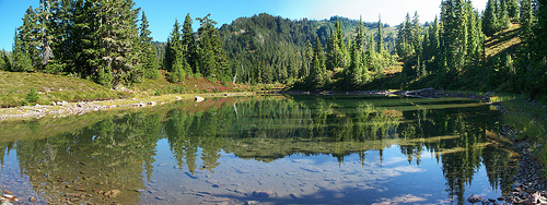
Soon I was hiking again and came to another lake, could this be the Deer Lake I see on the map? More photos of the nice reflections on the lake and I was off again.
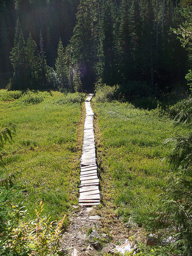
Not much further and I see a little wooden boardwalk style trail going through a marshy area and I see a sign that says welcome to Deer Lake.
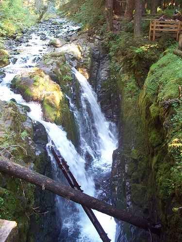
Oh good, now only a little over 3 ½ miles to go. Up to this point in my hiking career, the farthest I have ever hiked was a trip I did when I was much younger up to Flapjack Lakes and back which, if memory serves me correctly is about 16 miles round trip. On this hike I felt pretty tired at about mile 12 but once I got to around mile 16 I felt like a second wind had come on. Down the trail I went, deeper into the valley towards the Sol Duc. I eventually came to a bridge crossing the Canyon Creek which the trail follows from Deer Lake. Not much farther now. I finally reached Sol Duc Falls. There were people milling about and I felt kind of sorry for them. Sol Duc Falls is pretty but nothing compared to what I had seen today. Oh yeah, as an afterthought I took a picture of the falls too.
Only .7 miles to go! Up ahead I saw someone that looked familiar. It was the day hiker that I passed going the other way at the top of the divide. I called to him and he slowed down to let me catch up so we could chit-chat. I compared notes with him and found out that he started hiking only five minutes earlier than I did. Upon further investigation I discovered that he had been to several of the same hikes that I had done this year. We both hiked Burroughs Mountain at Mount Rainier on the same weekend. We both hiked some of the same hikes in the gorge this spring. We both hiked Umtanum over near Yakima this year. What a small world, and how odd to go in different directions of the loop starting and ending at almost the exact same times. Before I knew it I was back at my car. The time was 4:40 PM so I was pretty close to my estimation of 9 hours hiking time. What a great hike. Maybe I will do it again next year from the other direction.
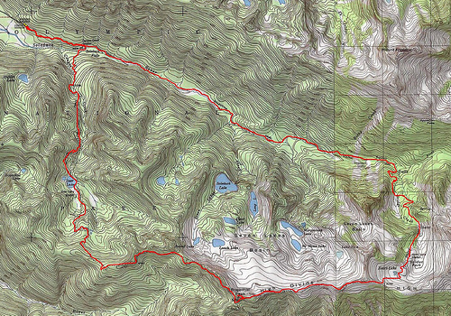
This trip report is dedicated to the memory of my brother Jeff Steveson.
Aug 25th 1959 – Sept 19th 2009
Rest in Peace Brother






This is lovely. Thank you so much.
Love hiking this region. First made the trip from Sol Duc to Hoh in 87. Back then, Bogachiel wasn’t crowded at all! In fact, we didn’t cross paths with a single hiker until he hit the Hoh River trail…ah those were the days!
One of my favorite areas, and still not too crowded!
Thank you for your great story. Sorry about your brother.
I’m hoping to hike this loop soon.
Go for it. Right now is a great time of year to hike it. Thanks for the kind words.