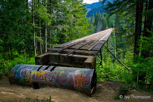
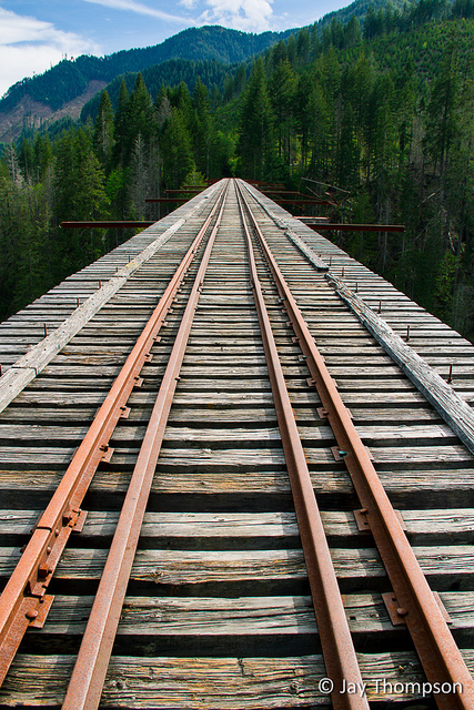
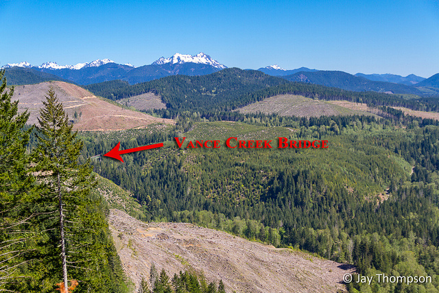
The Vance Creek Bridge is an abandoned railroad bridge in the South East Olympic Mountains. At 347 feet high, it was the second highest railway bridge ever built in the United States. I didn't have the nerve to walk out on it very far. I'll let the pictures speak for themselves.

Roll mouse over image. No mouse?


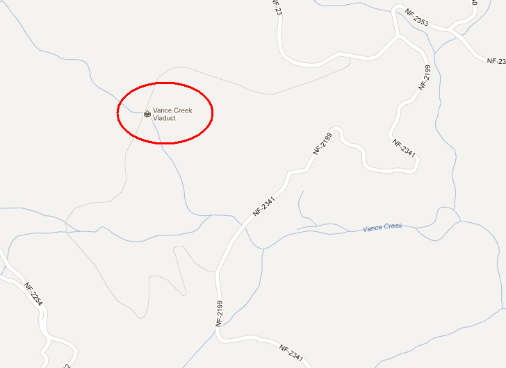
Maps are for entertainment purposes only. I don't recommend walking on the bridge or hiking out to it since I don't really think the Simpson Lumber Company wants people going out there. With that said, it's not too hard to find directions on Google.
Aug 18 2014 update
Seattle weekly reports that the bridge is now officially closed to the public. http://www.seattleweekly.com/home/954313-129/instagram-favorite-347-foot-tall-thatnwbridge-officially-closes
On Aug 2nd, someone who goes by the name 'fisinstan' left the comment below. - "Everyone should know that access to the bridge is now closed and people are being arrested for trespassing in the area. Too much garbage and vandalism. Stay away the security guys are there everyday."
Not sure if this guy is genuine or just one of the Simpson flunkies but his Gravatar appears to be fake and he filled in his email address as 123@hotmail.com. I usually trash bogus or fake comments but I found his to be a little funny so I let it stay. OK Simpson, you got your free quote out there. Pretty sure we all knew we were'nt supposed to be out there anyways but thanks for the tip.

very nice
there used to be a big (tall) bridge east of castle rock near mt st Helens. now there is a high way there. on the way to the visitors centers. it was before out time. not sure what the height is. but it is tall. it was how they got the logs down the mountain to the saw mill.
Been there, done that (many years ago).
Hi Jay,
How do you create the roll-over google topo maps on your webpage?
Hi martin,
Do you mean the third image on this page or the map on the bottom of the page? The third image is made with a wordpress plugin called hover image. I think it uses some javascript or something. It is basically two images wrapped in some special tags and the hover image plugin takes care of the rest.
If you are talking about the map at the bottom of the page, that is a different WordPress plugin called xml google maps. Basically you upload a gps file in GPX format and the plugin adds the map using google data.
If you don’t use WordPress, I’m afraid none of this will do you much good.
Good Luck,
Jay
Hi Jay,
I’m traveling out this way next week. Is it a pretty easy trail to follow with it not being marked? And its about four miles total right?
Thanks!
Yes it is very easy to follow. 3 1/2 – 4 miles at most round trip.
What about parking? Do you park in the side of the road? Doesn’t look like they want people going up.
Yep. Just park alongside the road. You’re right, I don’t think they want people going out there, but unless they build a fence around it or take it down, I don’t think people will stop going out there.
Everyone should know that access to the bridge is now closed and people are being arrested for trespassing in the area. Too much garbage and vandalism. Stay away the security guys are there everyday.
Everyone else should know, if you leave a comment on my site, at least have the cajones to leave a real email address. This guy didn’t, I bet he is a Simpson employee.
Jay, If it was a Simpson/Green Diamond employee I think he would have contacted you at your about/contact page. They did contact me with all their name, title address and such. Sad it is closed now I used to climb the lower parts.
Perhaps you are correct.