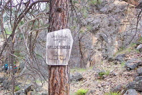
Lakeshore Trail
Lake Chelan Sawtooth Wilderness
May 10th and 11th 2008
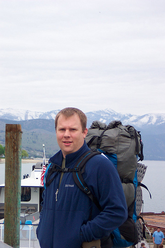
After a bowl of Raisin Bran at my hotel’s complimentary breakfast, my wife Dawn drove me the three minutes down to the Lady of the Lake ferry dock and said her goodbyes. I think she was almost as nervous as I was concerning what I was about to undertake. “Are you sure he will be OK out there?” she asked the ferry cashier as I handed her my money for the 8:30 am departure. I was about to go on my very first solo overnight backpacking trip and we were both a little apprehensive at what I was about to undertake. I gave Dawn a kiss goodbye and walked to the end of the dock to have my picture taken in front of the Ferry.

Once aboard, my concern deepened as there was hardly any one else on the ferry. I only counted about ten other people on board and none of them had backpacks like me. I was hoping that there would be others out on the trail with me in case something bad happened so I would not be totally by myself out there. Looks like I might truly be alone out there this weekend, just me and the rattlesnakes and maybe a bear or two. Soon the ferry captain made an announcement that he would be making a stop at Fields Point to pick up seventy-five high school kids going on a trip to Stehekin for the weekend as a school sponsored trip. Those of us who had a preference where we wanted to sit should take a seat before we get there. I was very relieved to see about ten backpacks on the dock when we arrived at Fields Point and soon I was talking with some other hikers sitting near me who drove to Lake Chelan the previous night from Bellingham.

None of us had ever hiked the Lakeshore Trail before, but reports the others had heard indicated that this was a great trail to hike. A few ups and downs, but for the most part the trail is said to follow the edge of the lake the whole way, the whole eighteen miles into the little hamlet town of Stehekin nestled at the end of the lake between the mountains of the North Cascades. The first time I had heard of Stehekin was when I was flipping through some old National Geographic magazines I had picked up somewhere. I believe the year Stehekin made its debut to the world through that magazine was 1974. Fast forward to 2007, Stehekin gets phone service for the first time. You could say it’s remote, and with only around 100 permanent residents, I’m surprised they got phone service at all. Only two ferries in and out per day. You miss those and you spend the night, like it or not.

My plan for the weekend was to be dropped off at the trailhead at Prince Creek and hike for five or six hours and camp at either Moore’s Point at 10 miles or Flick Creek at about 13 miles. Once at camp I would refill my water, cook dinner and set up camp for the night. In the morning I would get up around 5:30 or 6:00, eat, break camp and set off for the final miles of trail to Stehekin to catch my ferry back to Chelan at noon. This is the express boat that would get me into Chelan around 2:45. If I missed this one I would have to take the slow boat which would drop me off in Chelan at 6:00. I really needed to catch the fast boat so I would have time to drive back to my home in Silverdale which is on the other side of the mountains.

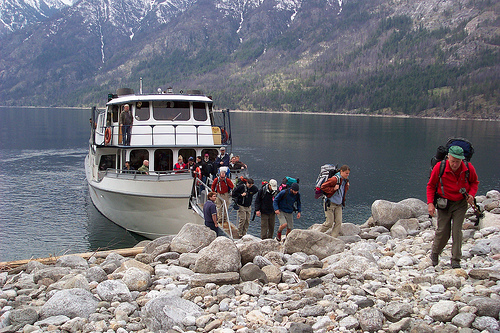
Right around 11:00 am the ferry deviated from its middle of the lake course. We were headed for shore, this must be Prince Creek. To say I was stoked would be an understatement. I had been doing day trips every weekend since the beginning of March in the hopes I could get myself into shape for an anticipated circumambulation of Mt St Helens later this summer. This trip would be a barometer of sorts for me to test new gear and my physical conditioning for the upcoming trip. It had been quite a few years since my last backpacking trip and I was a little unsure how well I would do. Lakeshore Trail would prove to be a good test. The boat landed and after a short walk down the ramp we were getting our packs ready.
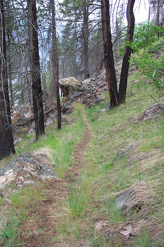
The first mile or so felt like a race hike as I was right on a group’s heels. Being a narrow trail along a hillside there was little room for the group in front of me to step aside to let me pass. There was a group behind me as well. We all needed to spread out and the narrowness of the trail was preventing this. I was not trying to be the fastest on the trail by all means but I did want to “hike my own hike” as the saying goes and not be slowed down by others or slow anyone else down either. At a switchback room was found for the people in front of me to let me pass. At the next switchback I let the group behind me pass. Hopefully there would not be too much leapfrogging. I wanted to go at a pretty good clip but I wanted to be able to stop and take pictures or catch my breath from time to time as well.
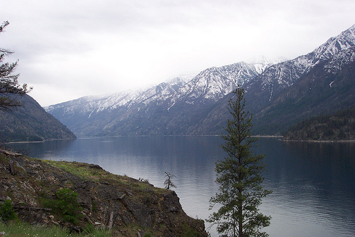
About three or four miles in, I was going uphill and needed to catch my breath, so I paused at the top of a switchback. Standing there, reflecting on the hike so far and the beautiful view of the mountains across the lake, I heard a rustling in the grass to my right. Looking down I see a snake slithering uphill to the protection of its rock and lookout, an apartment with a view. Rattlesnakes are reviled and with good reason, a bite from this little guy would surely ruin my hike as well as someone else’s who would have to go for help. The truth, is that rattlesnakes are just scared animals and will leave you alone usually unless they feel threatened or get stepped on.

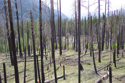
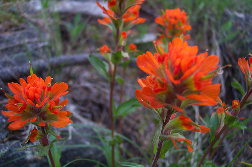
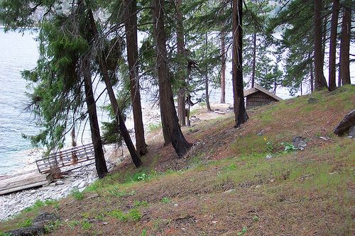
The mountains here between Prince Creek and Moore’s Point are on the dry side. The farther you go and closer you get to Stehekin, the more lush the vegetation gets. Being the early part of May, lots of flowers were out. I won’t pretend to tell you which ones I saw because their names are unknown to me. A lot of the trail goes through sections burned in forest fires, most due to lightening strikes and one by a campfire. This leaves much of the under story free of shrubs and gives good views of the lake and surrounding mountainsides. A lot of the trees have survived the fires as only the lower sections of their bark are burned, but on a few sections of the trail, the trees have totally been destroyed by fire. On a conservative guess, I would say at least 60% of the trail goes through burned sections. This should not, however keep you from visiting the trail as the views of the surrounding mountainsides and the lake are stunning to say the least.


Around five or six miles in, I arrived at Cascade Creek which I had to ford or find a log over which I could cross. This was the second or third creek that I’d needed to ford so far as bridges here apparently were few and far between and due to the snowmelt this spring, the creeks were quite swollen. Someone had already placed a couple of logs across the creek so I planned on using these to cross. With the aid of my trekking poles, crossing should have been no problem but as I placed my weight on one of the logs it shifted ever so slightly and when I compensated for this the weight of my pack threw me off balance and into the creek I went. I only went in up to about mid thigh and my pack stayed dry but this was another good lesson why it’s always safer to travel in pairs. I now had to hike 10 plus miles and I had soaking wet shoes. Luckily I packed more socks and my shoes being non-Gore-Tex would be dry by tomorrow, still I had five or six miles to walk tonight in wet shoes. I was going to get the thing I dreaded most, blisters.
At around ten miles my feet were mighty sore and I was quite tired when the trail came near some flat ground. This was the first flat ground I had encountered since Meadow Creek Shelter at mile six or seven. Did I mention the weird variation in mileage I noticed when I arrived on trail? The sign at Prince Creek said 18 miles to Stehekin but all the maps and books I have looked at say 17 or 17.2 miles. This is why I’m unsure of my mileage for most of the trail. Anyhow as I was saying, I was getting tired and reached some flat ground when all of a sudden there were two trails running parallel to each other. Looks like a road, but no cars can get back here so why is there a road in here? Looking down towards the lake and more flat ground I see some signs. I guess that I must be at Moore’s Point but when I stop to fill a water bottle at a creek, I enquire from some other hikers that have caught up to me if they know if its Moore’s Point and they are like “no, its someone’s house, didn’t you read the sign it said private property keep out”. Wow, I finally ran into my first genuine Hiker Snobs since being on the trail. This elusive Pacific Northwest creature in on the rise it seems. Hopefully these will be the last I encounter this trip. This encounter really put me in a foul mood and I just wanted to get to camp and have some dinner.

Once I reached the real Moore’s Point, my mood improved even though the Hiker Snobs were also going to camp there. The campground was quite large and I was determined to sleep as far away from them as possible. At one time there was an inn built here on the point but it got washed out by a freak flood of the nearby creek. After some dinner I went to work filtering my water for the next day. My 2 liter hydration bladder worked really well but I ran out of water towards the end of the day. Luckily I was only going about 7 miles tomorrow so I doubted I would run out. After dinner and some chores I set out to put my tent up and hang my food from a high branch in a tree. I’m not sure a determined bear would not be able to get it, but at least it wasn’t in my tent with me. I got in my tent around 8:00 to read and was asleep by 9:00. I remember being woke up around 1:30 by rain, it was pouring outside but my new tarptent was keeping me plenty dry. At around 3:30 I woke to hear the wind outside howling. It was blowing like crazy. What a terrible nights sleep I was getting. Around 4:00 it blew so hard that one of my tent pegs came out and my tent collapsed. I managed to reach out the door and put the peg back in the ground and put a big rock on it to keep it from coming out again. I did the same to the other side. After this I managed to get the tent back up by propping up the trekking pole I was using to hold it all up. The wind was blowing so hard that even though I was warm and dry in my tent, I could still not sleep and ended up getting out of bed around 5:30 and calling it a night.

With the long night behind me, it was time to get back on the trail. So after breaking camp and a quick breakfast, I was hiking once again. It was cold out now that I was outside of my sleeping bag. The weather forecast earlier in the week predicted the temperature in the low 40s at night. I would be warm soon however as the trail had plenty of uphill sections that would warm me up. By 6:30 I was back at the junction of the Lakeshore Trail, but when I reached for my camera to take a picture of the creek and bridge at the junction, I discovered my camera was gone. Not just my camera, but my camera bag as well. For some reason I did not clip my hip belt together when I left camp and my camera bag slipped off somewhere between the junction and camp, a half mile away. Luckily it was sitting on the trail just about half way back to camp and soon I was back at the bridge snapping a few pictures.


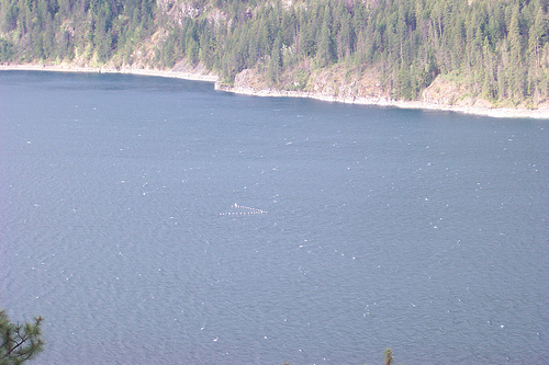
Much of the rest of the day was uneventful. I paused to catch my breath at one point and looked out at the lake and saw a perfect v shape flying up the lake. Some kind of white birds were flying towards Stehekin. Around 8:30 I hiked up some switchbacks and came over a bluff and got my first view of Stehekin and the end of the lake some 3 or 4 miles off in the distance. The end of the lake looked like a huge beach from here as the lake level was pretty low and it looked like a little dust storm was going on due to the high winds that were still blowing from last night.

About 3 or 4 miles from Stehekin I reached the Flick Creek camp and shelter but I did not linger as it looked like someone was still camped there. Above the shelter on the trail I saw some fresh cougar scat. It looked as if a cougar may have spent the night on the trail watching the campers contemplating an easy meal. As I left the camp area about maybe 300 yards past the shelter I paused to catch my breath and as I looked down towards the lake a saw a tent by the water that I had not seen before. Standing next to the tent, I saw an embarrassed lady in her underwear rushing to get her pants on. Oops! On I hiked.


At around 10:30 I finally came to a building that had some cars parked around it. I had arrived in Stehekin less than 24 hours after my drop off time yesterday. I quickly found the ranger station and went into the bathroom to change my clothes and get out of my thermal underwear since the wind had died down and it was warming up. A quick check of my aching feet revealed only one blister had developed.

When I walked over to the little store and restaurant I ordered some lunch and went over and bought a souvenir magnet to put on my fridge at home. At 12:00 I boarded the Lady of the Lake Express and was on my way back to Chelan and my waiting family.
How to get there
FROM SEATTLE TO BOAT CO. DOCK:
You may take either Highway 2 over Stevens Pass or Interstate 90 over Snoqualmie Pass.
Via Interstate 90; take I-90 east to Cle-Elum, take Exit 85 to Highway 970 over Blewett Pass. At the stop sign, turn east on Highway 2 toward Wenatchee for approximately fifteen miles. Take the Highway 97 Alt. exit, toward Rocky Reach Dam, and Lake Chelan. Continue on 97 Alt for approximately forty minutes. The Lady of the Lake is located on the left, as you come into the 30 mile per hour speed zone.
Via Highway 2; take Highway 2 from Seattle over Stevens Pass, approximately 150 miles. At Wenatchee, take the exit for Highway 97Alt. toward Rocky Reach Dam and Lake Chelan, driving approximately forty minutes. The Lady of the Lake is located on the left, as you come into the 30 mile per hour speed zone.
FROM SEATTLE TO FIELD’S POINT LANDING:
You may take either Highway 2 or Interstate 90.
Via Interstate 90: Take I-90 east to Cle-Elum, take Exit 85 to Highway 970 over Blewett Pass. Pass. At the stop sign, turn east on Highway 2 toward Wenatchee for approximately fifteen miles. Take the Highway 97 Alt. exit, toward Rocky Reach Dam, and Lake Chelan. Approximately nine miles North of Entiat, turn left at mile marker 223. You will travel nine miles over what the locals refer to as the Navarre Coulee Road to a STOP sign. Turn left and follow the road up lake. Field’s Point is seven miles, on the right.
Via Highway 2: Take Highway 2 from Seattle over Stevens Pass, approximately 150 miles. At Wenatchee, take the Highway 97 Alt. exit, toward Rocky Reach Dam, and Lake Chelan. Approximately nine miles North of Entiat, turn left at mile marker 223. You will travel nine miles over what the locals refer to as the Navarre Coulee Road to a STOP sign. Turn left and follow the road up lake. Field’s Point is seven miles, on the right.
FROM SPOKANE TO BOAT CO. DOCK:
You may take either Highway 2 or Interstate 90.
Via Interstate 90: take I-90 west from Spokane, then take the exit for the city of George to Highway 281. At the second stop sign, turn right on Highway 281 toward Quincy. At Quincy, turn left onto Highway 28 to the Wenatchee area. Highway 28 comes into East Wenatchee. Follow the signs to Highway 97Alt, and Lake Chelan. Stay on Alt. 97 for approximately 40 miles. The Lady of the Lake is located on Highway 97 Alt just inside the 30mph. Zone on the left.
Via Highway 2: take Highway 2 from Spokane to Highway 97, at Orondo. Turn right onto Highway 97 and travel to the Beebe Bridge crossing the Columbia River. Once over the bridge, take a left to Highway 150 and follow the signs to Lake Chelan. After approximately four miles you will come to a STOP sign, turn left and stay in the left lane. At the STOPLIGHT, turn left, (Highway 97 Alt ). Take Highway 97 Alt approximately one mile. The Lady of the Lake located on the right side of the Highway
Other Things to consider
April and May are considered the best time of the year to hike the Lakeshore trail to view the flowers. Late September or early October, before it gets too cold are good times to see the fall colors. The trail is hikeable in the summer but it can get very hot so I don't recommend it. Also the warmer the weather the more trouble you will have finding a camp spot as all the boaters will have taken them. Lakeshore trail is in rattlesnake country, so you will want to keep your eyes on the trail and watch where you step. Bears and Cougar are also active in the area so plan accordingly. You will also want to watch out for ticks, Deet is recommended. This is a wilderness area. There are no phones or cell service, so once you get dropped off you are on your own.

Jay — I work with the Boat Company and we are revamping our website, and I wondered if you’d be willing to share a picture on one of your blogs with us? We’d be happy to give you photo credit. Its the one of all the backpackers getting off the Lady of the Lake.
Hi, sorry so late to respond. I didn’t get a notification that someone left a message. Yes, if its not too late, you are welcome to use the image. Credit: Jay Thompson